Kosraean Pihlengfong
Mahkontowe has resided in the minds of Kosraeans as long as oral histories have been shared in Kosraean pihlengfong (night stories). In the story of the Loat (whale) and her daughter, Mahkontowe, comes the formation of Lelu Island (notice its shape is that of a whale); however, the origin of the story comes from the home village of Mahkontowe referred to as Tafeut located in Utwe municipality. It is in the southern and one of the oldest parts of the island.
One day, Mahkontowe was washing her hair with kaki (coconut oil) and in the water a streak of oil could be seen (called kacmihs in Kosraean). Her mother, the loat followed the streak to Lelu. At the site of Lelu, the Tokosra’s (king of Kosrae) men clubbed the whale, leaving only a piece of her remaining. Mahkontowe brought the whale back to life with a piece remaining from the whale and a taro leaf of salt water.
Mahkontowe rode the loat trying to escape the southern Polynesian Islands via the Marshall Islands but the Tokosra cast a strong spell on the loat which made her return to Kosrae. The whale tried to escape again, this time being pulled back and formed the island of Lelu. Mahkontowe was so very sad that she went into the mountains and fell asleep.
Sometimes Mahkontowe can be referred to as the Sleeping Lady and at times there has been mention of four children who came from the Sleeping Lady. While Mahkontowe and Sleeping Lady may be told as different stories, they are the part of the same story. The origins of the story of the Sleeping Lady and her four children can be traced to the arrival of the missionaries when approximately 300 people remained on Kosrae. When the missionaries built churches, construction took place in the four villages (out of 40-60) with the largest remaining population. These villages were Lelu, Malem, Tafunsak, and Utwe–sometimes referred to as the four children.
Pihlehnfong are an important part of Kosraean cultural past and shared history. The Mahkontowe Conservation Area is the product of many elder’s contributions since 1823. Oral histories are created and passed on by people through time. Ethnography, or the scientific description of a human societies, offers glimpses into our past. Each oral history offers a piece of a shared story and over time offers more insight into our past. No two stories can be exactly the same and therefore, no one story can be the correct or incorrect story. A collection of oral histories is analyzed for common themes and outliers to better understand a group of people. Ethnographic data, including oral histories, are encoded with other codes. The collection of ethnographic data allows themes to surface and offers insight into our past. Kulo na ma lulap to all of our elders who offered their stories to share with Kosrae’s children and visitors alike!
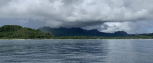
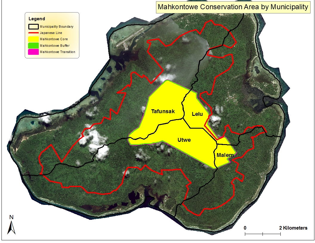
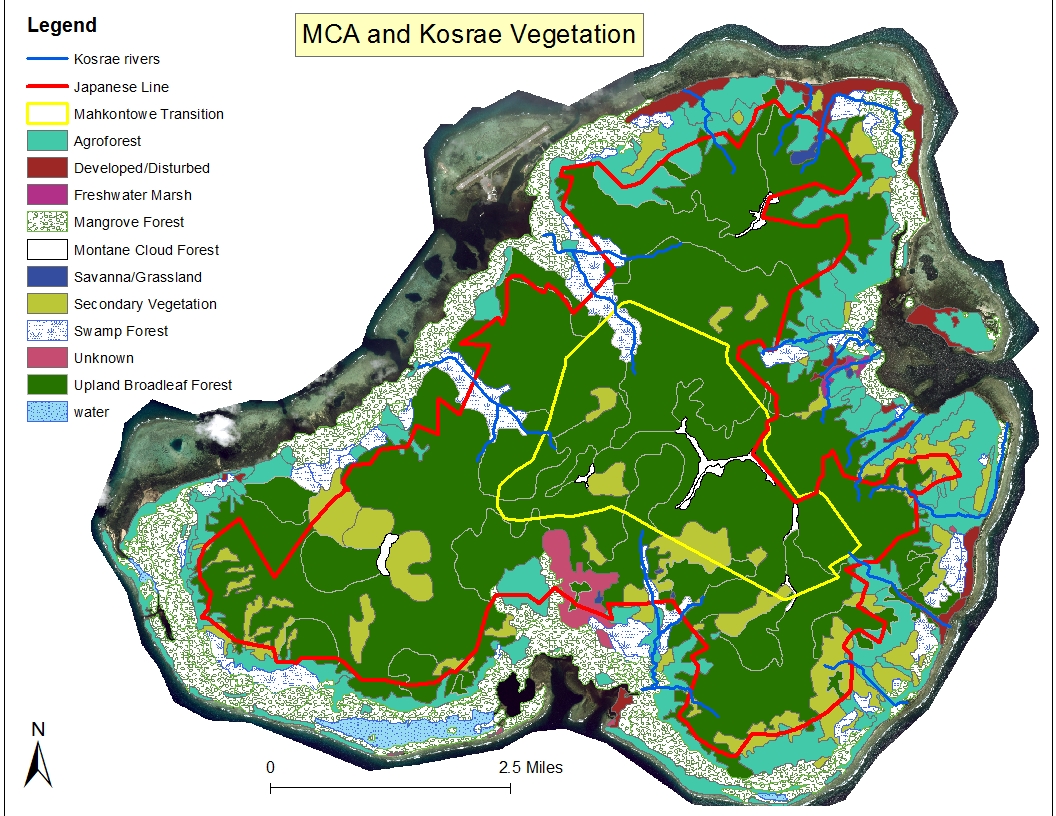
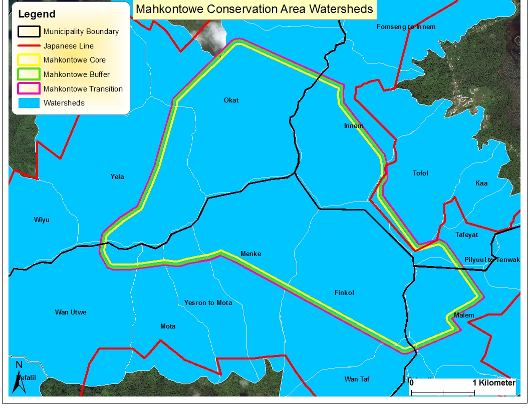
In honor of the loat, her daughter Mahkontowe, and Kosraean elders, the mountain chain on Kosrae running from west to southeast is known as the Mahkontowe Conservation Area (MCA)–home to many of the known ancient trails used by Kosraean ancestors which lead into the valleys and over the ridges of Mahkontowe. The MCA became protected through Kosrae State Law 11-156 on June 7, 2018. This area of 15 square kilometers hosts a variety of significant cultural, archaeological, and natural aspects whose conservation conserves and protects a Kosraean way of life.
The Story of Discovery
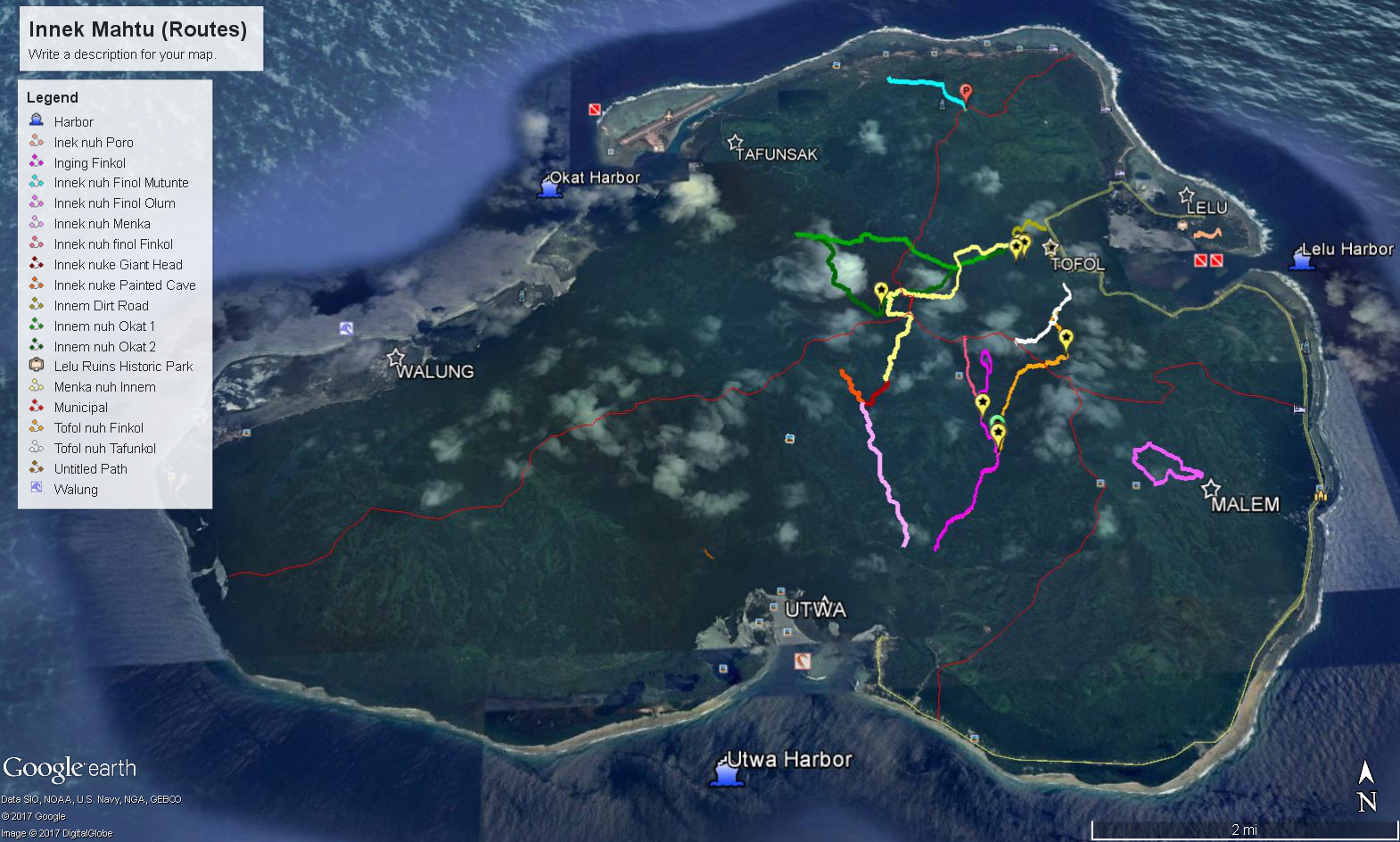
The Kosrae State Historic Preservation Office discovered some traditional Kosraean routes through oral history collection (fully supported by the National Park Service). These oral histories led to a collaboration between Kosrae State Historic Preservation Office team and Kosrae Association of Tourism Operators (KATO) to surface traditional routes throughout Mahkontowe. Some of these ancient routes continued to be utilized between 1824-1910 according to Kosraean reports collected by Dumont D’urville, Kittlitz, Sarfert. Additionally, Kosrae HPO identified an average of one new historic site per hike during a five month period (April-September 2017). The sites discovered and oral histories collected between May and August of 2017 indicate an elaborate trail system used by Kosraeans long ago which are best seen passing by basalt rock compounds found along the trails (Figure 2). This same set of trails interconnects communities nested around Mahkontowe for agricultural purposes, such as subsistence and food security.
Finol (Mountains) of Mahkontowe
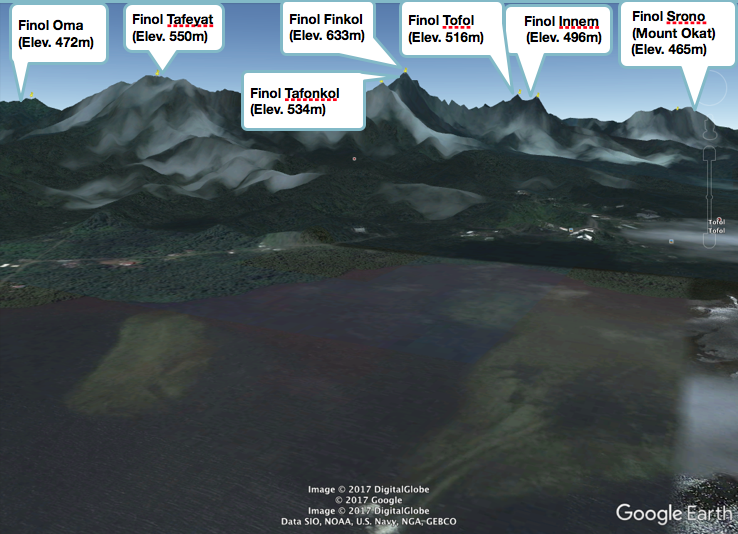
Finol Srono
In 1919, Sarfert recording the name of the head of Mahkontowe as Finol Srono. Since the Japanese mapped the largest island of Kosrae State, Finol Srono is also known as Finol Okat due to its proximity to Okat and its river.
Finol Innem and Tofol
These two mountains make up the breasts of Mahkontowe. On a survey conducted by the Kosrae State Historic Preservation Office in May 2017, a compound was discovered due west of this area in May 2017.
Menka Valley
The heart of Mahkontowe rests in Menka Valley. In this area, unlike anywhere else far in toward the foothills of the mountains, many residential compounds can be found. It is often thought Kosraeans did not reside in the mountains; while this may be true at some point, evidence of settlement, however temporary it may have been, the Kosrae State Historic Preservation Office discovered three new compounds in the foothills of Menka Valley and Finkol Valley over a three (3) month period (May 26-August 21, 2017).
Finol Finkol
Finol Finkol in kahs Kosrae refers to leadership and guidance that this mountain provided to mwet Kosrae, especially those residing on Lelu Island. The prefix fin- refers to a preposition meaning “in” or “on” while -kol refers to “head” as in leader or guide. Finol Finkol can be considered as the apex of contemporary Kosrae State.
Finol Tafonkol
In contemporary Kosrae, the name Tafonkol surfaces many definitions but is virtually unknown in terms of location, until recently; however, most Kosraeans understand it to be the naval of Mahkontowe. Archival research yielded a location for Tafonkol in May 2017.
Finol Tafeyat
Finol Tafeyat represents Mahkontowe’s lower abdomen. Per Kosraean naming practices, the section of each village closest to Lelu is always called Yattah, which refernces the center of the Insaru called Yat. Tafeyat contains two morphemes, tafu- meaning “half of” and -yat as a reverence to the saru of Lelu. Saru referes to a sacred place or place of worship. Infal Tafeyat was one of the Tokosra’s favorite bathing places.
Finol Oma
Finol Oma area according to local inhabitants is known as the womb of Mahkontowe due to the very red soil found here and the legs. Furthermore, there is a waterfall near here, at Olum.
Flora and Fauna in MCA
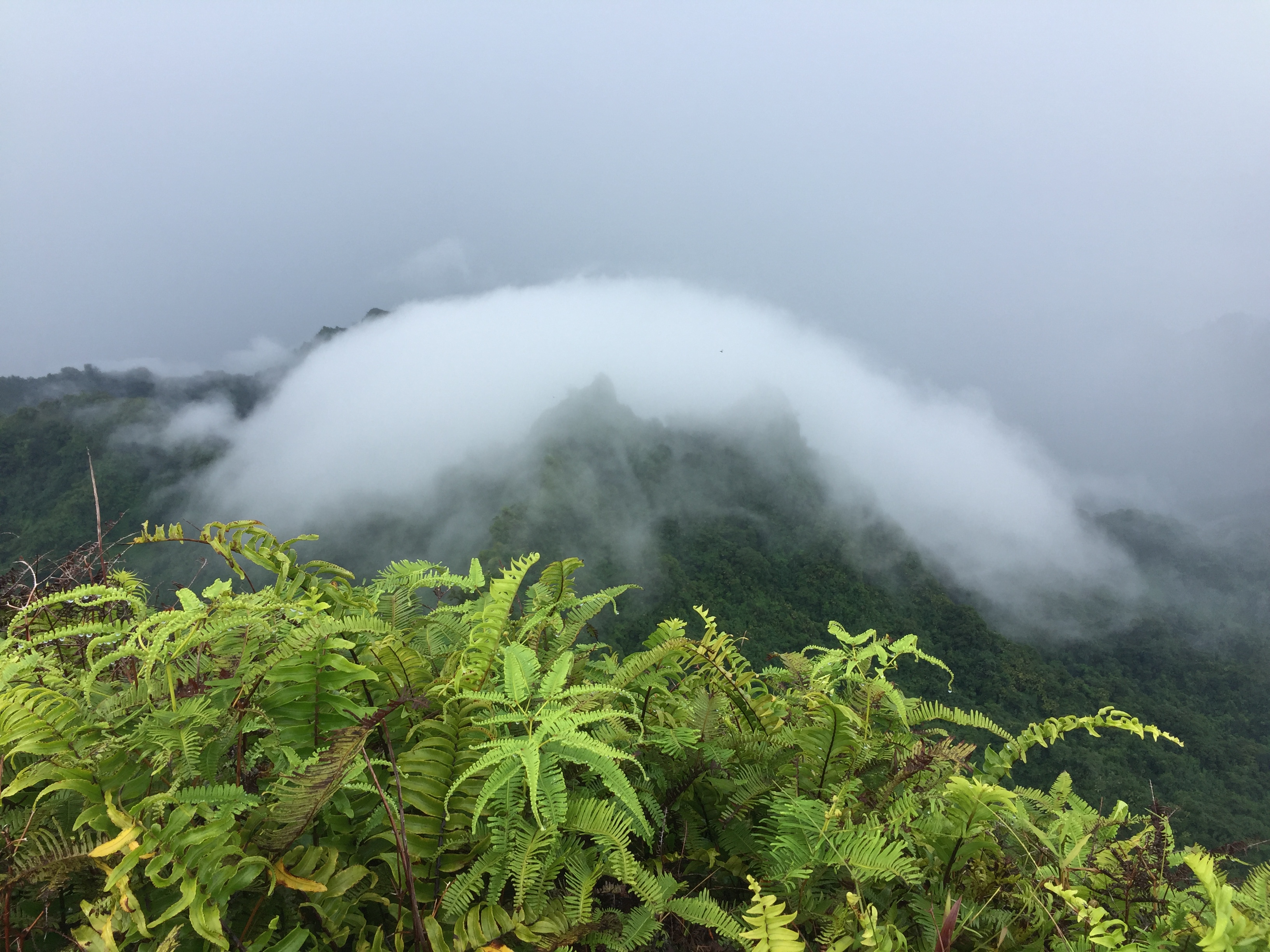
In addition to the cultural and archaeological aspects, the natural environment found within the Mahkontowe Conservation Area proved to be significant. The biodiversity of MCA is unique to Kosrae; it hosts one of the lowest lying cloud forests and home to several endemic species of animals and plants.
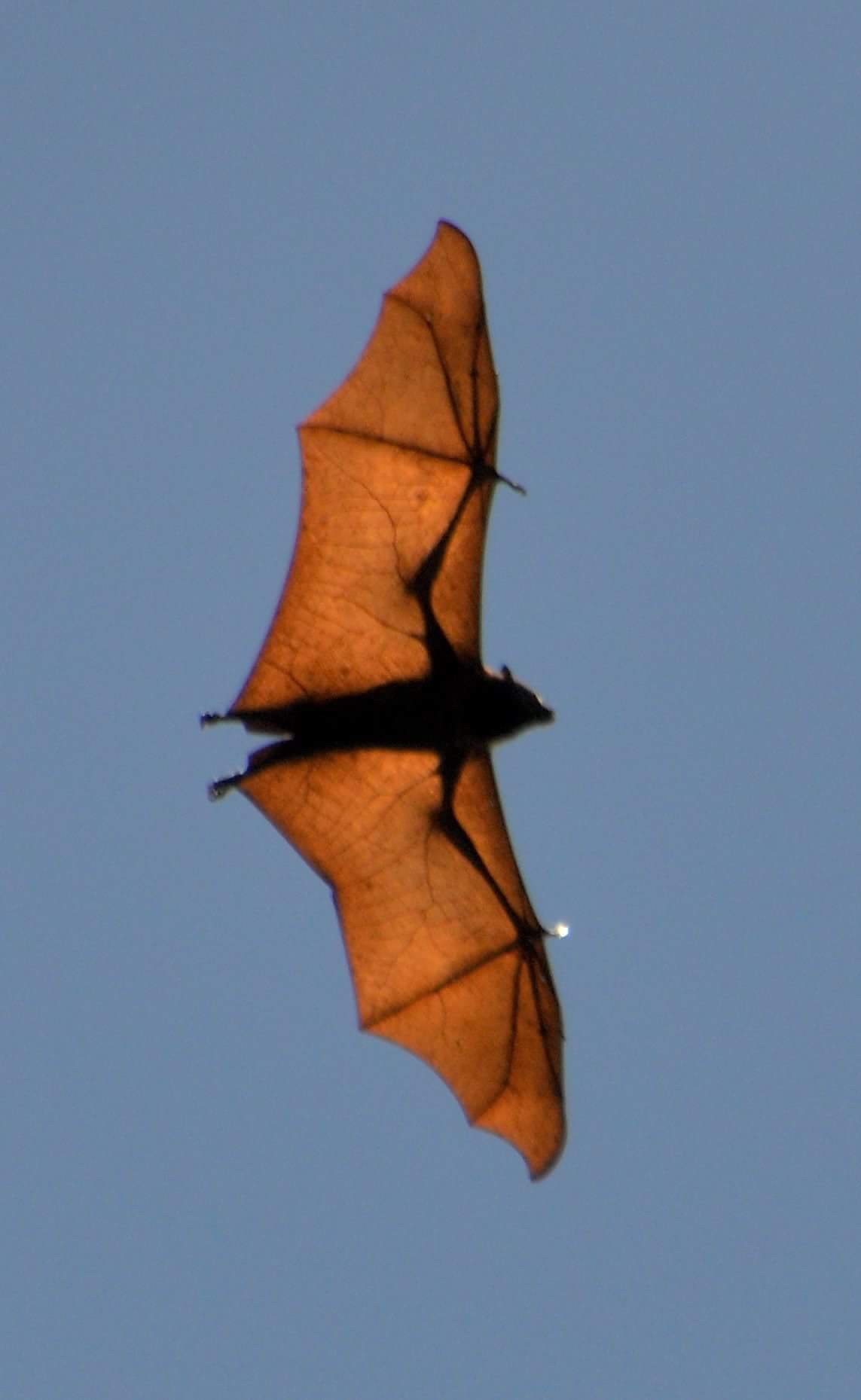
The MCA area is part of what is known as an Area of Biodiversity Significance (ABS) for Kosrae State. According to the Nature Conservancy, there are six conservation targets in Kosrae’s ABS: (1) the Arno skink, (2) Fern-sedge Savanna, (3) Kosrae flying fox, (4)Micronesian pigeon, (5) Mixed broadleaf forest, and (6) Montane Cloud Forest (Raynor et. al ND:79). In particular, the Nature Conservancy points out that the Kosrae flying fox, or fruit bat, is endemic to Kosrae. It is listed as a full species Pteropus ualans and a subspecies of the Marianas flying fox P. mariannus ualnsus (see Figure 2 below) and should therefore be protected as it is on the endangered species list. Kosraean fruit bats are a keystone species essential to the long-term survival of forests as they serve to pollinate and disperse seeds of forest species (Raynor et. al ND:65).
Development in these areas would encroach on the keystone species’ habitat as well as cause soil erosion and more frequent landslides due to the soil types found in the area proposed as the Mahkontowe Conservation Area.
The impacts of soil erosion can be great on Kosrae’s surface water resources by increasing sediments and pollution into rivers and streams. These changes have the potential to increase costs of water treatments; consequently, any action protecting and conserving forest cover in the island watersheds will ensure long-term water conservation with direct benefit to the island residents.
In addition, forest cover in the upper watersheds area provides ecosystem services such as regulating local climate, carbon sequestration, soil fertility and erosion, as well as providing food, raw materials and water supply to the Kosraeans. The services provided by the upper watersheds forest help alleviate household hardship associated with the shift from subsistence to cash economy. Loss of the services provided by the upper watersheds ecosystem will require households to replace those good and services by purchasing them, increasing household expenses.
Kosrae offers a wonder to the world in that there is much natural and historic resources left to discover in a unique and pristine island interior, providing a safe mysterious adventure for any visitor in an eco-friendly and sustainable manner. The establishment of Mahkontowe Conservation Area (MCA) represents a step towards conservation of natural resources that will allow for a continuous healthy supply of fresh water, fish for future generations, and cultural sustainability.
To reserve your hike, please contact the hotel at which you are staying.